
10 Year Land Subsidence Report

Ten years of your land's history. In one report. From space.

Land movement is often invisible until it's expensive - cracked foundations, a declined insurance claim, a stalled sale, or a price renegotiated after you've already committed. A LandSure report shows you what the ground has actually done for the past decade, so you find out before you buy, build, insure or sell - not after.
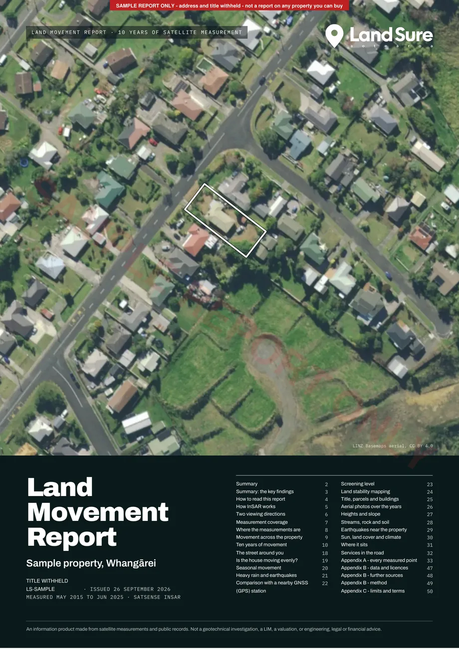
LandSure Land Movement Report cover, Edition 3 sample: the property on LINZ aerial imagery
Powered by ESA Sentinel-1 satellite data
NZ Sentinel-1 archive from 2014
NZ Owned
Delivered within 24 hours · checked by a person before it is sent

Why order a report

One report can save you from a very expensive mistake.

Land movement problems rarely show up on a standard building report or a drive-by. By the time they are visible, they are expensive. Here is what a LandSure report actually does for you.

1

What a report does for you

Negotiate from a position of knowledge

Buying a property? Use the report to negotiate price, request remediation, or walk away - before you are legally committed. Selling? A clean history report reassures buyers and can help you avoid a last-minute price drop.

2

Avoid a five or six-figure surprise

Underpinning, retaining walls and slope remediation routinely cost tens of thousands of dollars once movement is visible in a property. A report from $345 flags the same movement years earlier, while it still costs nothing to act on.

3

Protect your resale value and cover

Undisclosed ground movement is a liability at your next sale, and can complicate insurance claims down the line. A documented, dated history protects your position either way.

Please read before you buy. LandSure is not a geotechnical engineer, and this report is not analysis, certification or a professional opinion. Think of it as a canary in the coal mine - a satellite data report that flags where the ground may be moving. It is meant to be used alongside your local geotechnical engineer, who knows your area and the differences in the land. InSAR does not work equally well in all land types, so please check that this product is right for you before purchasing.

What does a LandSure report actually look like?

The sample report runs to 50 pages: a two-page summary, how to read the report, every measured point on its own card, the street around the property, and the land, title and area records behind it.

Report Highlighted Pages

Real pages from an Edition 3 LandSure report on a Whangārei property, with the address and title withheld. Report length depends on how many measured points your property has.
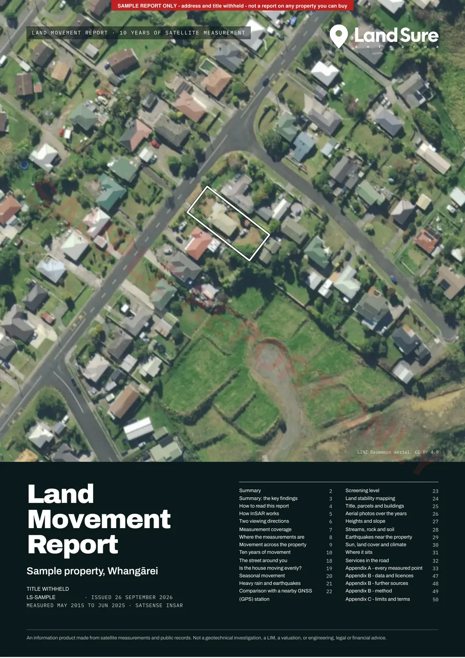
LandSure Land Movement Report cover: the sample property on LINZ aerial imagery, with the measurement period and contents

Cover - the property on LINZ aerial imagery, the measurement period and the contents.
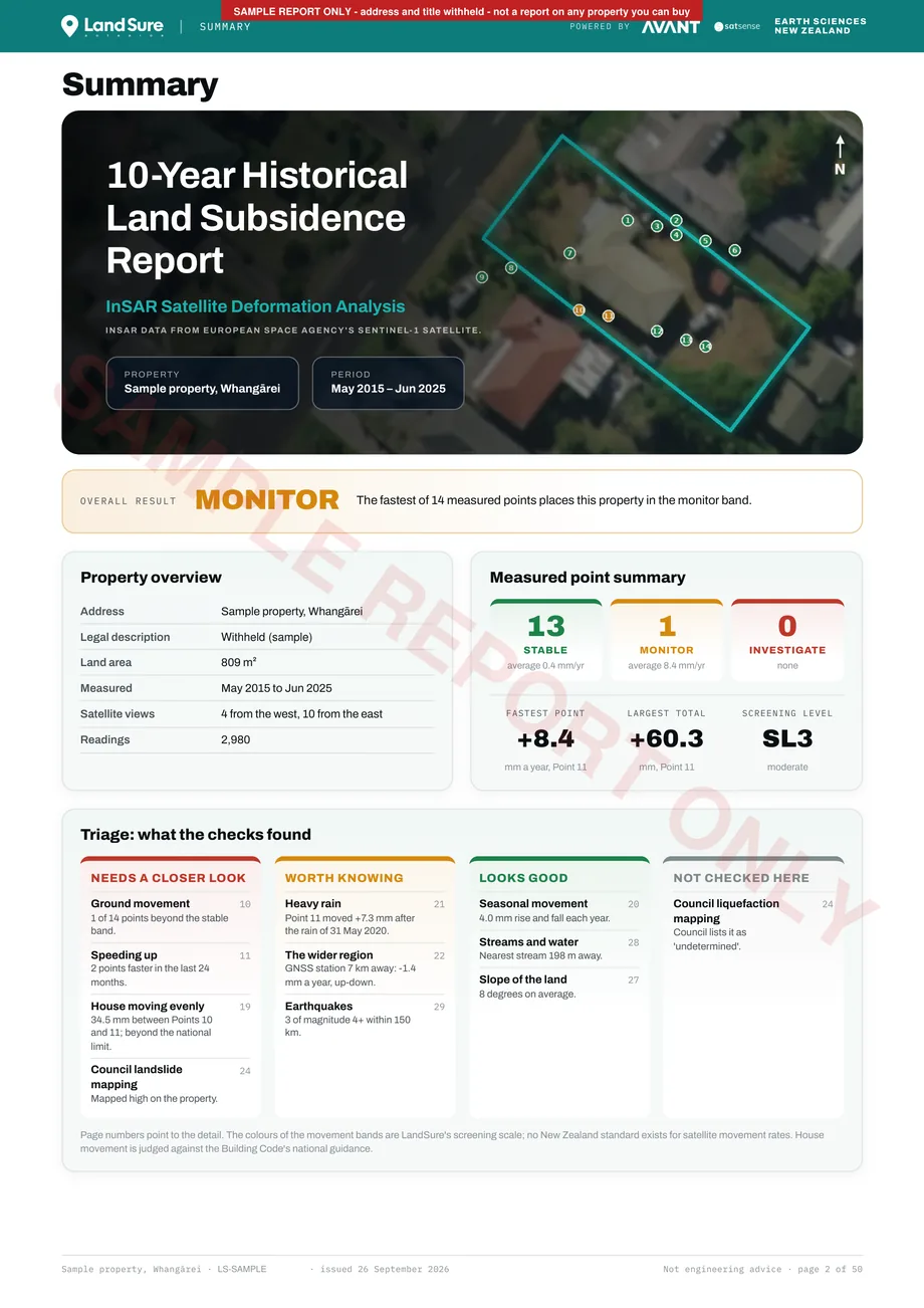
Report summary page: overall result, property overview, measured point summary and a triage of every check

Summary - the overall result, a property overview, the measured point summary and a one-glance triage of every check, with page numbers to the detail.
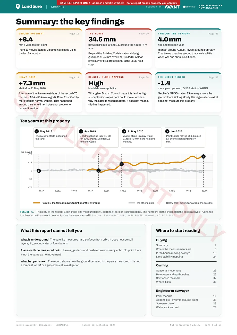
Key findings page: the story of the measured record at the property and what the report cannot tell you

Key findings - the story of the record at this property, and what the report cannot tell you.
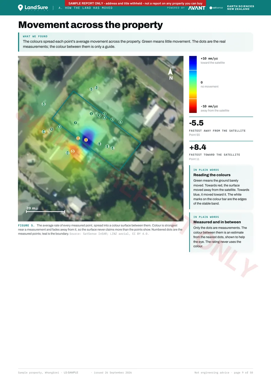
Movement across the property: each measured point's average rate spread into a colour guide over the aerial photo

Movement across the property - each point's average rate spread into a colour guide. The dots are the real measurements; the colour between them is only a guide.
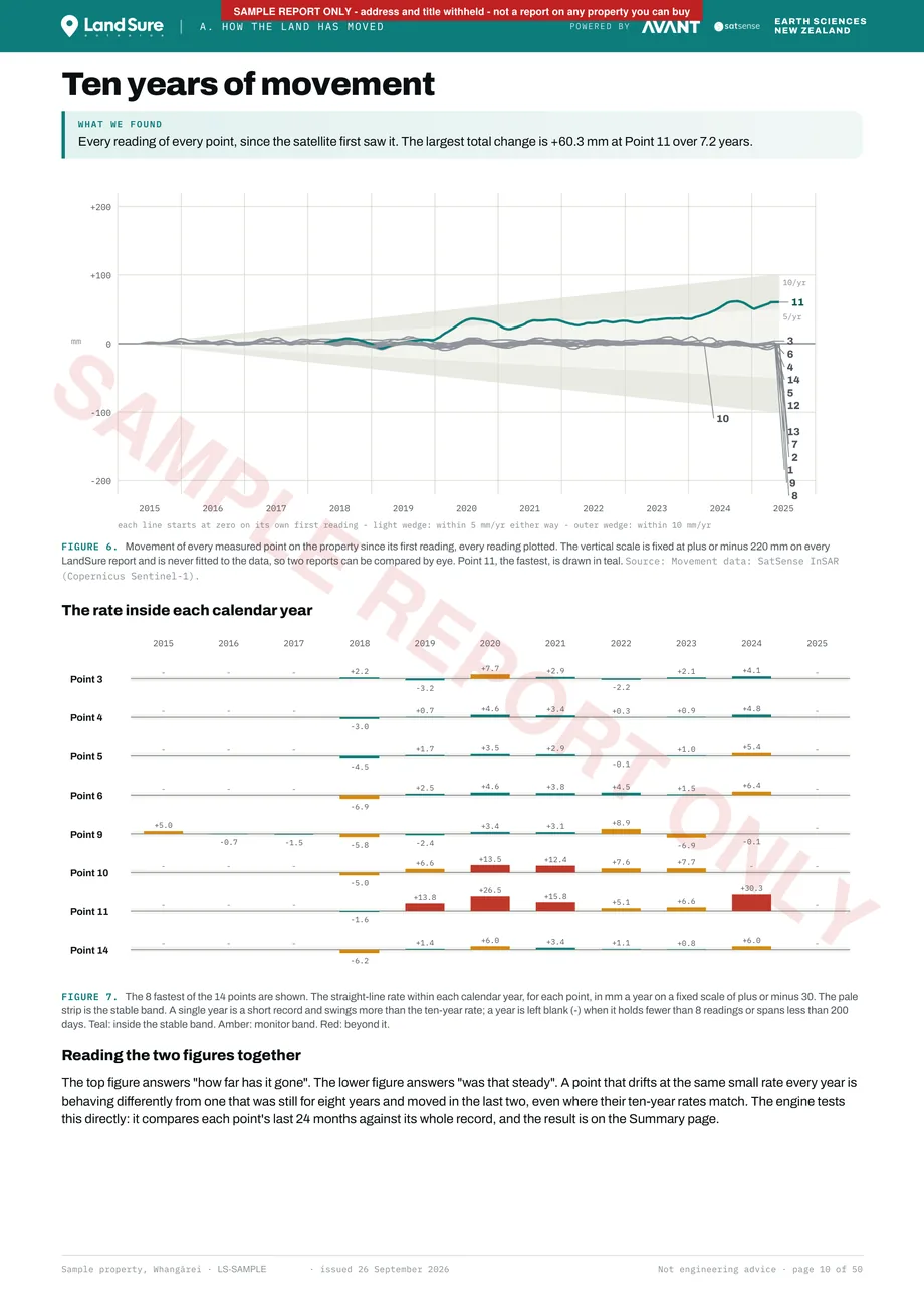
Ten years of movement: every reading of every measured point on one fixed scale, and the rate inside each calendar year

Ten years of movement - every reading of every point on one fixed scale, and the rate inside each calendar year.
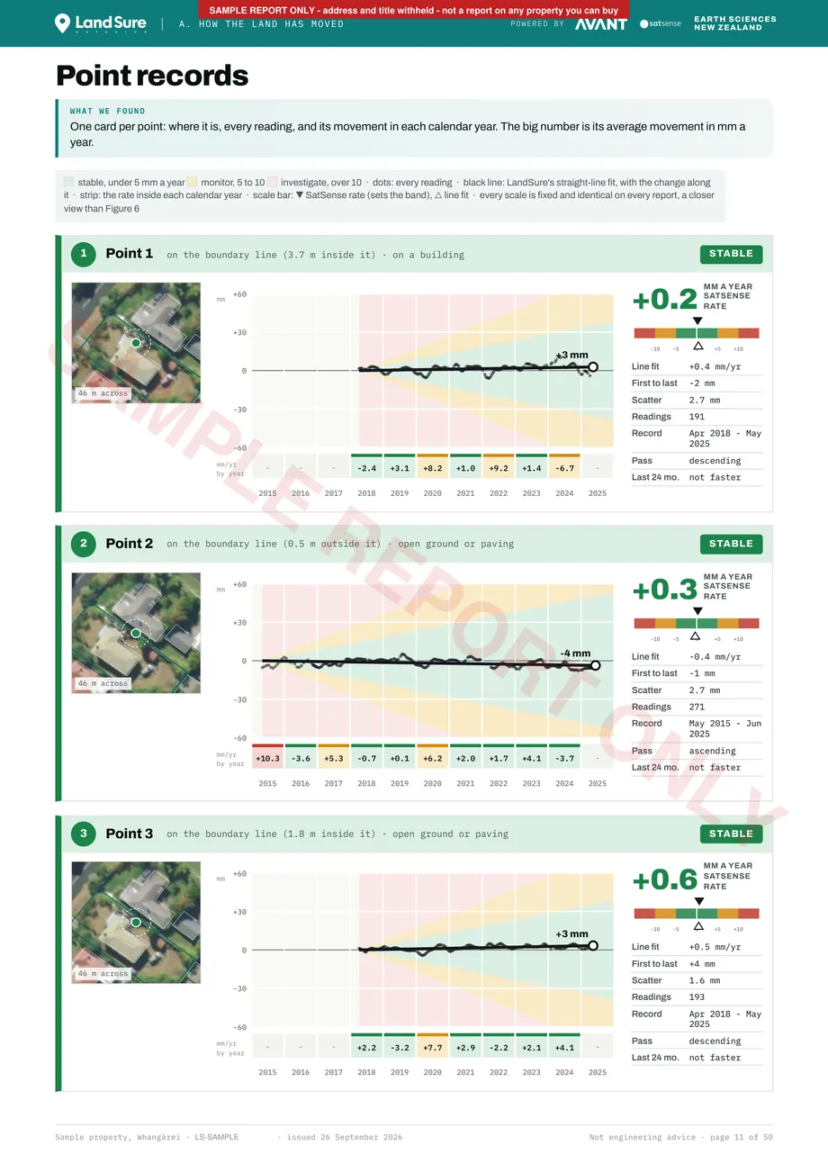
Point records: one card per measured point with its location, every reading and its movement in each calendar year

Point records - one card per point: where it is, every reading, and its movement in each calendar year.
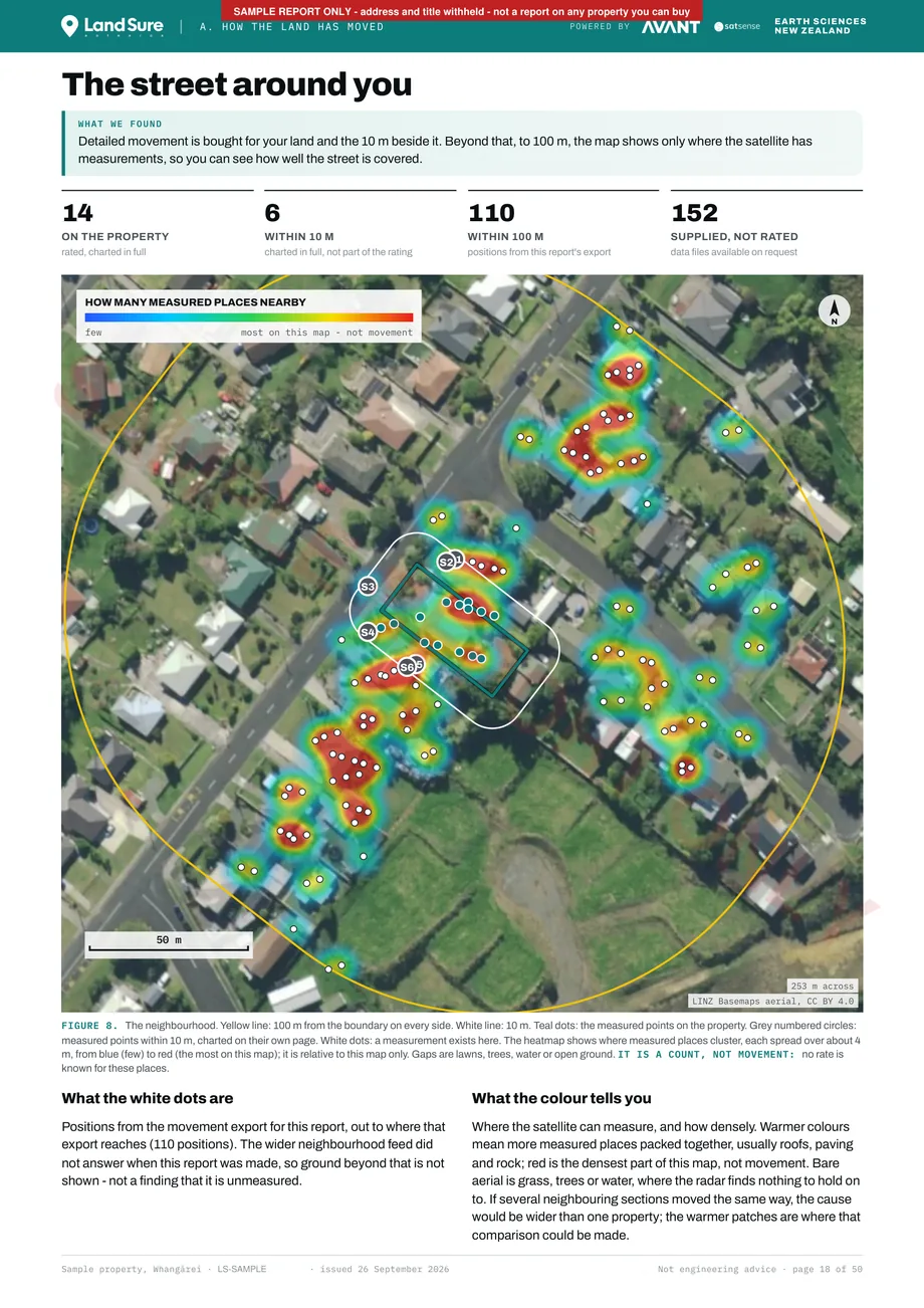
The street around you: measured points on the property and within 10 m, and a heatmap count of measurements out to 100 m

The street around you - full detail for your land and the 10 m beside it; out to 100 m, a count of where the satellite has measurements. A count, not movement.
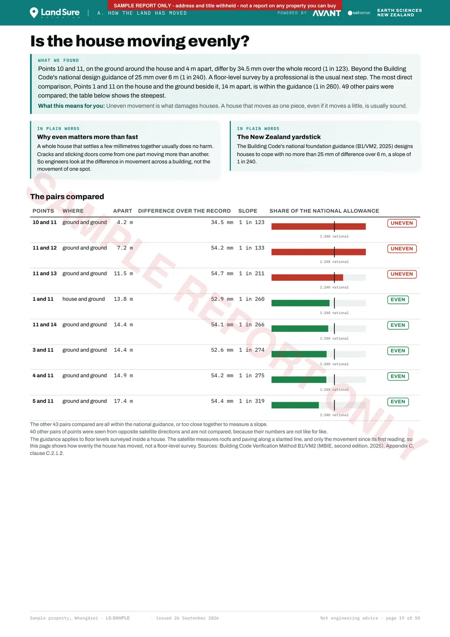
Is the house moving evenly: the difference in movement between measured points around the house

Is the house moving evenly? - the difference in movement between points around the house, compared with the Building Code's national design guidance.
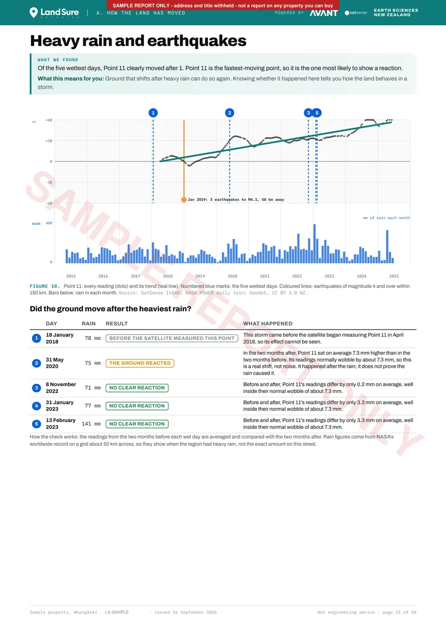
Heavy rain and earthquakes: whether the fastest point moved after the five wettest days, with nearby earthquakes marked

Heavy rain and earthquakes - whether the fastest point moved after the five wettest days, with earthquakes of magnitude 4 and over within 150 km marked.
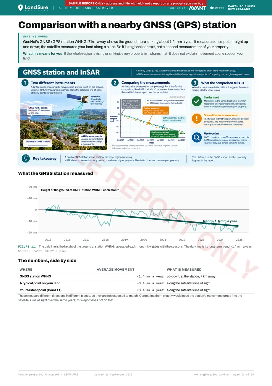
Comparison with a nearby GeoNet GNSS (GPS) station: the regional ground trend beside the property's measurements

Comparison with a nearby GNSS (GPS) station - what the wider region is doing. Regional context, not a second measurement of your property.

Download the full 50-page sample (PDF, 6 MB)

Why this matters in New Zealand

New Zealand land doesn't stand still. Most of the time, you can't see it moving.

New Zealand sits on the boundary of the Pacific and Australian tectonic plates. The land is compressed, lifted, sheared and stretched continuously - and it doesn't announce itself until something fails.

Landslides

Heavy rainfall saturating slopes is the leading cause of NZ property damage. Gradual hillside creep often precedes sudden failure by years. InSAR detects the slow movement phase.

Subsidence

The ground beneath a property sinks over time - due to drainage, tree roots, or underlying geology. Foundations crack. Driveways drop. Resale value falls.

Active fault movement

Auckland, Wellington, Kaikoura, Napier. Interseismic deformation accumulates slowly across NZ's fault zones. InSAR measures that background movement; it cannot predict when a fault will rupture.

Coastal slope movement

Properties near the NZ coastline sit on ground that can creep, slump and settle. Our report measures that ground movement. It does not measure shoreline or cliff-edge retreat - we do not offer coastal erosion reporting yet, so contact us if you need erosion data.

Volcanic deformation

The central North Island bulges and subsides with changes to magma bodies underground. InSAR measures that slow, wide-area movement from orbit.

441,000+
NZ residential buildings, houses and outbuildings, in flood hazard areas (NIWA / University of Auckland, 2023)
800,000
Landslides estimated from Cyclone Gabrielle, 2023 (Earth Sciences New Zealand, 2025)
12%
Of NZ's total housing value is in flood hazard areas

Sources: NIWA and University of Auckland (2023); Earth Sciences New Zealand (2025).

We'll be straightforward about what this technology can and can't do.

InSAR is not magic. It is a precise measurement tool with real capabilities and real constraints. Here is a straightforward, traffic-light view of where it excels, where it needs care, and where it is not the right tool.

InSAR is great at

  • Urban and suburban environments - buildings, roads and structures give excellent radar returns
  • Slow movement detection - gradual subsidence, creeping slopes and long-term settlement are exactly what InSAR is built for
  • Large-area screening - quickly identifies movement hotspots across whole properties or corridors
  • Historical trend analysis - 10+ years of data reveals patterns fieldwork would take years to establish
  • Post-event assessment - comparing pre- and post-event movement gives objective dated evidence
  • Stable, open terrain - exposed rock, dry ground and paved surfaces return strong signals

InSAR still works, with care

  • Dense native vegetation - bush and tree cover scatters the radar signal, reducing reliable points in forested areas
  • Steep terrain - very steep slopes change the signal geometry and can create shadow zones behind ridgelines
  • Active earthworks or construction - significant surface change between passes can cause signal loss until the surface stabilises

InSAR is not good when

  • Movement is very rapid or sudden - the 12-day satellite cycle means a sudden large landslide may not be captured until the next pass
  • Standing water is present - flat water returns very little signal, so wetlands or flooded areas may have few or no points

InSAR data does not replace a geotechnical engineer. It gives your geotechnical engineer a 10-year running start.

Where our report indicates movement, elevated risk or uncertainty - we will say so. Where a finding needs a professional to look at it, the report says so beside that finding. We are not in the business of telling people their land is safe when the data suggests otherwise.

Common questions about the report.

A LandSure report shows how the ground and the hard surfaces on and around a New Zealand property have moved over up to the last ten years, measured by satellite radar (InSAR) to a few millimetres a year. It also compares points around the house to show whether it is moving evenly. Start with the free property check to see where the satellite has measurements, then buy the report for the full record. It measures movement; it is not an engineering inspection and does not say why the ground moved.
A land movement report is a record of how the ground at a property has moved. LandSure's is made from Copernicus Sentinel-1 satellite radar processed by SatSense, and covers every measured point on the property, movement across the property, the street around it, whether the house is moving evenly, seasonal movement, heavy rain and earthquakes, and a comparison with a nearby GNSS station. It costs from $345 incl. GST and is delivered as a PDF within 24 hours.
Buyers use it for their own due diligence before they commit, to decide what to ask and whether to engage a geotechnical engineer. Owners use it to understand their land, and sellers to show a dated record. It is for the person who ordered it: banks, insurers and councils cannot rely on it, and it does not replace a geotechnical engineer's report.
Enter the address in LandSure's free property check. It shows the LINZ boundary, the price and where the satellite has measurement points. The report then gives each point's movement over up to ten years on LandSure's screening scale (no New Zealand standard exists for satellite movement rates). For the council's formal hazard information, get the property's LIM, and for any concern, ask a Chartered Professional Engineer.
Fitted movement rates are typically accurate to a few millimetres a year, and to about one millimetre a year in the best case: a stable reflector with a long, unbroken record. Every rate is measured along the satellite's line of sight - toward or away from the satellite, not straight up and down - and single readings carry several millimetres of scatter. No field survey can match its 10-year retrospective record - but for absolute levels, conventional survey methods remain the reference.
The Sentinel-1 archive over New Zealand starts in 2014, so a report can cover up to about ten years. Not every point has that long: a point's record starts when its surface first appears (a new roof or driveway starts a new record), so the report prints each point's own dates and never calls a shorter record ten years.
Dense native bush or tall trees can reduce the number of reliable measurement points, because radar scatters off vegetation rather than returning cleanly. Lawns, gardens, pasture and bush often have no readings at all. The report shows exactly where points were found, counts them, and says plainly which parts of the property could not be measured. No point in a place is not the same as no movement there.
Significant surface change between passes can cause temporary signal decorrelation, which usually resolves once the surface stabilises. The report identifies any such gaps or anomalies in the time-series and explains them clearly.
No. LandSure provides displacement data and satellite-based analysis only. We are not licensed geotechnical engineers and the report does not constitute engineering advice or certification. Where the report indicates movement or risk, we recommend engaging a registered geotechnical professional. Think of it as the desk study that tells you exactly where to direct specialist fieldwork.
The data comes from ESA's Sentinel-1 constellation, processed by SatSense (Leeds, UK) - a world-leading InSAR company co-founded by University of Leeds Professors Tim Wright and Andy Hooper. AVANT applies New Zealand-specific geology, hazard records and analysis to produce your final report.
Yes - many buyers order one as part of their own due diligence. The report is issued to you and is for your use only: banks, insurers and councils cannot rely on it, and it will not satisfy any requirement for a certified engineer's report. What it gives you is ten years of measured movement history, so you can decide what questions to ask - and whether to engage a geotechnical engineer - before you commit.
Within 24 hours of order confirmation. Every report is checked by a LandSure team member for the right property, complete data and correct output for quality control before it is sent, so you are never sent an unchecked automated output. Complex large-area professional assessments may take up to 48 hours. You receive the PDF report and your tax invoice by email. Data files are available upon request.
You can order a report for any property in New Zealand, but coverage varies. Measurement points only form on hard, stable surfaces such as roofs, paving and rock; bush, pasture, water and snow return no readings. The free property check shows the measured positions around your address before you buy.
If the data shows concerning movement, the summary on the first pages says so, gives the screening level and points to the page with the detail. Where it matters, the report says what the usual next step is - for example a floor-level survey or advice from a geotechnical engineer. It measures movement; it does not say what caused it or who is responsible. We do not soften findings to make a sale.
We never sell your data. To run the check and make your report we use a few service providers, and each receives only what its job needs: SatSense (UK) receives the property boundary to run the satellite query; Google Maps finds the address you type; Stripe takes payment; our order alerts (Slack) and our customer list (Make and a Google Sheet) hold your address and email so we can make your report and follow up about your check. The website runs on Cloudflare, our forms are delivered by Formspree, and Google Analytics measures how the site is used. The full list is in clause 12 of our terms. Your details are held under the Privacy Act 2020.
Yes - and we recommend it for properties with any detected movement. The LandSure InSAR Land Monitoring service (launching soon) provides continuous 12-day monitoring with SMS and email alerts. Properties that start with a historical report can transition seamlessly to active monitoring.